Recent searches
Search options


FOSS #maps based on #OpenStreetMap are very close to fully replacing Google Maps for me. OpenStreetMap is often more complete and up-to-date than Google, and when it's not, I'm happy to help improve it. Once I pick two endpoints in Organic Maps or GNOME Maps, routing works fine (even for public transit, so long as that transit authority is supported).
The problem is just searching for #addresses or named destinations. That's the only reason I use Google Maps. Is there any fix on the horizon?

@skyfaller Address data is very resource-intensive to acquire, even when locales have "good" parcel GIS data. I'm debating writing an app to take Tarrant County parcel GIS data and overlay it onto OSM for getting areas and nodes to have *some* kind of address data on them. But so far, it's just an idea in my head. I actually *don't* want to "automate away" this problem; I *want* human beings being the authority on whether any particular proposed address is likely correct or not. #gis #osm #OpenStreetMap #FortWorth #dfw

@aspensmonster @skyfaller address data is near and dear to me. Apps like OrganicMaps use fallbacks to help fill gaps so even getting things into OpenAddresses can help.
My semi-manual review process for OSM is outlined here (https://www.openstreetmap.org/user/watmildon/diary/401407) but there’s lots of other ideas in this space. I am glad you are being thoughtful about it!

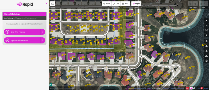
@watmildon @skyfaller That MapWithAI tool is interesting. But I'm a skeptical commie that doesn't like BigTech :P Why are Facebook (and even worse, ESRI) dedicating resources to this effort? Do they offer up their ML models, hi-res sat photogrammetry, other data, and code for local use? Or are those hidden away in a networked back-end somewhere?
Basically, I'm not interested in doing free labor for BigTech, which is honestly what the tool feels like. They get to refine their ML models with labeling from highly trained and accurate analysts that would otherwise cost a pretty penny (at scale, anyway). And OSM gets? One-time infusions of data, with (potentially) no way to maintain and improve upon the process without their continued blessing. Not the best trade in my view. ¯\_(ツ)_/¯
@aspensmonster @skyfaller the data layer in this example from MWAI is just National Address Database (available from US DOT). If you have your own data you don’t need the plugin and can follow the rest of the steps. It just happens to be a connector to the ESRI NAD endpoint. No ai involved.
I encourage you to read it a bit more with thay lens and not immediately jump to “this is free labor for meta” which it absolutely isn’t.
@watmildon @skyfaller Fair enough :) Perhaps the JOSM plugin is not as suspect as the Rapid Editor (https://rapideditor.org/) that pops up when searching around for MapWithAI, which has source code that calls out to lots of different back-ends, and even some with encrypted backend URLs. In any event, perhaps I'll take up that "just in my head" project and build an alternative :D
@aspensmonster @skyfaller yeah. The conflation piece is the real magic of course.
I have run through about a million addresses this way and it’s very good at finding typos in house numbers and road names. Human entry also comes at some cost, clumsy beings that we are.
Folks in San Francisco used parcel boundary data as additional hinting in their import but lots of places dont have suitable parcel data 
No perfect solutions but we march onwards.

@aspensmonster @watmildon @skyfaller
Neither Facebook nor the @linuxfoundation offer any relevant bits of their tool chains as open source/open data. Oh and RapiD etc. use proprietary ESRI protocols for data access.